GNSS signals arrive from over 20,000 km away at astonishingly low power, which is why a $20 gadget can blind a receiver. Here is how jamming works, what the hardware specs look like, and what actually defends against it.
What Is a GNSS Signal Jammer and How Does It Work?
A GNSS signal jammer is really just a radio transmitter that drowns the satellite navigation bands in noise, and the physics behind why that works is almost embarrassingly simple. GPS L1 leaves the satellite at around 14.4 dBW, but after traveling more than 20,000 km through space and atmosphere, it shows up at roughly -157 dBW, with a typical received strength near -130 dB. So the receiver is basically straining to hear a whisper, and any local transmitter shouting on the same frequency wins the argument instantly.
That asymmetry is what makes jamming such a lopsided game. A satellite transmits at roughly 14.4 dBW, but by the time the signal reaches your antenna—after traveling more than 20,000 km—it's down to about -157 dBW, a loss of over 170 dB. A signal that faint is easy to drown out, and you don't need a lab or a defense contractor to do it. Commercial jammers marketed as privacy tools sell online for as little as $20, and the cigarette-lighter models that plug right into a car's 12V socket go for around $150. Picture trying to shout down a whisper from across a stadium: the person whispering can't raise their voice, but anyone in the stands can show up with a megaphone. These aren't exotic military systems—they're consumer electronics that just happen to sit on protected spectrum. Turn one on, and nearby receivers lose their lock on the satellites. No lock means no position fix, and for timing receivers that rely on GNSS as a clock reference, no accurate time either.
The frequency bands involved here are well documented. GNSS satellites broadcast across three main bands: L1 at 1575.42 MHz, L2 at 1227.60 MHz, and L5 at 1176.45 MHz. Each band carries its own set of signals, and a jammer really only has to overpower whichever band the target receiver is using. That detail matters more than it might seem at first, since most consumer-grade gear—phones, vehicle trackers, drones, timing units—leans on L1 alone. Which means a single low-power transmitter aimed at that one frequency can take out a surprising range of equipment over a surprisingly wide area. The reason comes down to signal strength: GNSS signals travel more than 20,000 km from orbit and show up incredibly faint, averaging around -130 dB, so even a modest burst of noise on L1 is enough to drown them out.
| Band | Frequency | Typical Use |
|---|---|---|
| L1 | 1575.42 MHz | Consumer devices (phones, trackers, drones, timing units) |
| L2 | 1227.60 MHz | Higher-precision and dual-band receivers |
| L5 | 1176.45 MHz | Advanced, safety-of-life and high-accuracy applications |
Jamming vs Spoofing: Key Differences and Real-World Impacts
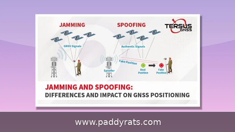
Jamming and spoofing tend to come up together, but they actually break a receiver in two very different ways. Jamming drowns the GNSS band in noise, and since the satellite signal is already incredibly faint by the time it reaches the ground, it gets buried — the receiver can't compute a position or time at all. The upside is that it usually knows something's wrong: it flags loss of lock or falls back into holdover mode. Spoofing is the sneakier one. Rather than overpowering the real signal, it broadcasts counterfeit GNSS signals designed to look like the genuine article, so the receiver locks onto them without complaint and reports a position or time that's quietly off. That's the distinction that really matters out in the field — jamming makes itself known through signal loss, while spoofing can go unnoticed for a long time unless you're running dedicated monitoring. The 2017 Black Sea incident is a textbook example: more than 20 vessels near Russia's Novorossiysk port showed positions displaced by hundreds of kilometers, and spoofing did all of that in silence.
The consequences of jamming and spoofing aren't just theoretical—they show up in the real world, and they can be serious. Back in 2017, more than 20 vessels near Russia's Novorossiysk port on the Black Sea reported GPS spoofing that put their positions hundreds of kilometers from where they actually were. A few years later, in 2022, a GNSS interference event near Dallas-Fort Worth Airport threw off aircraft navigation across a wide area—a good reminder of how fast one incident can ripple through busy airspace. And the problem seems to be getting worse. According to Air Pilots Safety Briefing Note 18, issued on July 7, 2025, 41,000 spoofing events were reported in just a 30-day stretch during 2024, clustered in a small share of global airspace.
The economic stakes here are huge. According to Rand Corporation research, the Houston construction sector alone could rack up losses of up to $85 million per day during a widespread GPS disruption—which makes sense once you consider how much modern surveying, machine control, and logistics rely on precise positioning. GPS-guided weapons, meanwhile, lose 30–60% of their accuracy across an area of 50,000 square kilometers. And there's an interesting pattern in the data: jamming power picked up steadily starting in 2017, as observed through radio occultation, but dropped sharply once the Russo-Ukrainian War broke out. It's a good reminder that interference levels tend to follow geopolitics more than they follow technology trends.
GNSS Jammer Types, Signal Characteristics, and Specifications
Jammers fall into a few technical families, and the family a given device belongs to says a lot about how hard it is to detect and shut down. Start with the simplest one: the continuous wave (CW) jammer. It parks all its energy on a single frequency and just sits there pumping out noise. Narrowband jammers spread a little wider, occupying roughly 2 MHz, which is enough to swallow an entire GNSS channel instead of a single point. Sweep or barrage jammers move across a range of frequencies to catch several signals at once, essentially trading peak power for coverage. Then there are chirp jammers, the fast movers of the bunch — they sweep frequency rapidly, usually somewhere between 1565 and 1585 MHz, which explains how one cheap device can disrupt several GNSS services at the same time. Directional jamming aims its energy at a specific target rather than spraying it in every direction, and modulation techniques shape the interference itself so that each watt does more damage. In the real world these categories tend to blur together, but a jammer's design still tells you plenty about how easily it can be spotted and taken off the air.
| Jammer Type | How It Works | Typical Characteristics |
|---|---|---|
| Continuous wave (CW) | Transmits on a single frequency | Simple, narrow impact, easy to spot on a spectrum display |
| Narrowband | Occupies roughly 2 MHz of bandwidth | Covers a full GNSS channel rather than one point |
| Sweep / barrage | Moves across a range of frequencies | Catches multiple signals at once, lower peak power per frequency |
| Chirp | Sweeps frequency rapidly, typically 1565–1585 MHz | Can disrupt several GNSS services simultaneously |
| Directional | Concentrates energy toward a specific target | Higher effective power at the target, harder to detect elsewhere |
| Modulation-based | Shapes the interference signal itself | More effective per watt of transmitted power |
Power output and antenna count are what really separate cheap consumer gadgets from serious hardware. Take a basic cigarette-lighter jammer—the kind you can buy online for around $150. It typically broadcasts on the L1 band at roughly 10 mW, which is enough to confuse a receiver sitting nearby, but it's hardly a broad threat. Hedgehog jammers are the opposite extreme: packed with multiple antennas, they broadcast on L1 or L2 at around 10W and sometimes jam WiFi and cellular signals too, which makes them far more disruptive over a wider area. Then there's the high end. Stratign GNSS jammers claim a range of more than 100 km and cover GPS, GLONASS, COMPASS, Galileo, IRNSS, and QZSS—putting them in strategic territory rather than local troublemaking. Field testing gives a sense of where the practical spread lands: the weakest jammer affected tracking at around 300 meters and acquisition at around 600 meters.
| Jammer Type | Band(s) | Power | Claimed Range | Notes |
|---|---|---|---|---|
| Cigarette-lighter jammer | L1 | ~10 mW | Local (hundreds of meters) | Consumer-grade; sold online for as little as $20–$150 |
| Hedgehog jammer | L1 or L2 | ~10 W | Wider area | Multiple antennas; sometimes also blocks WiFi and cellular |
| Stratign GNSS jammer | GPS, GLONASS, COMPASS, Galileo, IRNSS, QZSS | High-end | >100 km | Portable, modular, upgradable to regional systems |
The table below rounds up the key specs for the main product categories, so you can see at a glance how a $20 privacy device stacks up against a vehicle-mounted unit or a regional system. It covers transmit power, band coverage, range, and the countermeasures each class of hardware can defeat — the kind of details that tend to decide what actually makes it into a procurement review or a threat assessment.
Where GNSS Jamming Happens: Aviation, Maritime, and Road Tolling
Jamming doesn't spread evenly across the globe — it clusters in specific regions, and researchers have mapped those clusters in remarkable detail. The hotspots include the western Black Sea, the eastern Mediterranean, the Baltic Sea, western Russia, western Ukraine, the Arctic Sea north of Finland and northern Norway, and the border region between India and Pakistan. These aren't random occurrences; they tend to track military activity, territorial disputes, and state-level electronic warfare programs. To keep tabs on all of this, GPSJAM publishes a daily interference map compiled from crowd-sourced aircraft navigation data. Since pilots and aircraft systems automatically report navigation anomalies, the map offers a near-real-time snapshot of where jamming is active on any given day — and it has become the de facto public reference for tracking the problem worldwide.
Aviation feels it first because aircraft depend on GNSS for navigation, approach, and timing. Defenses include falling back to VOR, DME, and ILS, radar vectoring, pilot reports, disabling GNSS position updates, and switching off terrain look-ahead systems that would otherwise generate false warnings. Maritime traffic suffers similar disruption, as the 2017 Black Sea spoofing incident showed, and road tolling systems that rely on GNSS positioning are vulnerable to the same interference.
The European GNSS Agency's Strike3 project logged 450,000 interference events over two years across 23 countries, of which 73,000 had significant impact and 66,000 came from jammers. That dataset remains one of the most cited bodies of evidence that interference is routine rather than exceptional, and it explains why timing-dependent industries such as telecom and financial transactions now treat GNSS disruption as an operational risk.
Anti-Jamming and GNSS Resilience Techniques
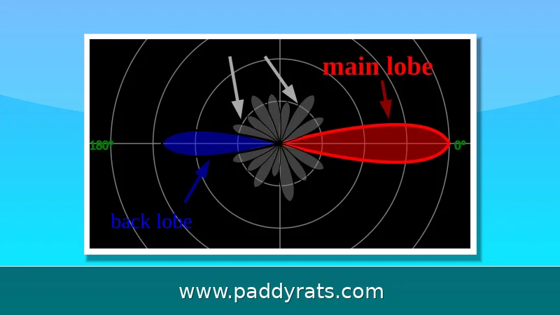
Anti-jamming technology works by making the receiver smarter rather than louder. Null steering creates a zone of silence toward the interference source, effectively tuning the antenna pattern to ignore the jammer while still receiving legitimate satellite signals. This is typically paired with multi-element antennas, signal-processing algorithms, and inertial navigation system integration so that a receiver can coast through short outages without losing its position solution.
Commercial systems show what is achievable. The infiniDome GPSdome counters up to three simultaneous jamming sources, operates on dual bands such as L1/L2 or L1/G1, and adds latency of about 100 nanoseconds, which is negligible for most positioning applications. Controlled Reception Pattern Antennas, or CRPA, are the standard military-grade countermeasure against GPS jamming. On the signal-authentication side, Galileo OS-NMA allows receivers to verify that signals genuinely come from Galileo satellites, while GPS Chimera adds digital signatures to the civil signal.
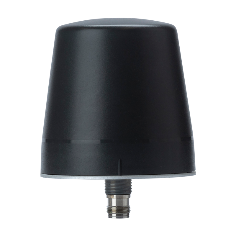
For timing receivers specifically, resilience is an engineering discipline. Meinberg's GPS Optical Antenna Link supports cable lengths up to 2,000 meters, and physical antenna separation helps avoid simultaneous jamming of redundant receivers. Engineers also recommend a good oscillator for holdover, dual GNSS receivers with separated antennas, and low-angle blocking antennas that reject interference arriving from ground level, where most jammers sit.
Detecting and Geolocating GNSS Jammers
Detection starts with monitoring rather than mitigation. Spectrum monitoring platforms such as CRFS RFeye can identify interference signatures and help geolocate the source, while handheld monitors like the GP-Probe Nano L1 provide real-time alerts through LED, sound, and vibration with up to 30 days of battery life. These tools matter because a jammer that is never found cannot be shut down, and regulators need evidence before they can act.
Testing resilience is equally important, and the EN16803-3 replay technique is the standard approach. It assesses a receiver's detection sensitivity to a range of interference profiles, including CW, NB, PCW, WB, PWB, and MS signals. Running these tests before deployment tells an operator whether a system will fail gracefully or silently, which is often the difference between a manageable outage and a safety incident.
The practical workflow is straightforward: baseline your receivers, replay known interference profiles, log detection thresholds, and repeat after any firmware or antenna change. Organizations that do this consistently, including research groups at the University of Texas at Austin Radionavigation Lab and KTH Royal Institute of Technology, tend to catch degradation early. For anyone operating drones, survey equipment, or timing infrastructure, that discipline is cheaper than discovering the problem during an outage.
Risks, Compliance, and What Operators Should Do
Jamming is illegal in the United States, and the reasons go beyond spectrum ownership. Jammers can prevent someone from dialing 911, crash drones, and disrupt law enforcement communications, which is why the FCC prohibits their sale and operation. The same logic applies in most jurisdictions, even where enforcement is inconsistent and low-cost devices remain easy to buy online.
The operational risk list is long: GNSS jamming affects aviation, maritime, construction, telecom timing, and financial transactions, all of which depend on precise time or position. For organizations that need continuity, the practical playbook is multi-constellation and multi-frequency receivers, signal authentication such as Galileo OS-NMA, spectrum monitoring, geofencing, sensor fusion with inertial navigation, and Controlled Reception Pattern Antennas where budgets allow.
None of this eliminates the threat, because a 10 mW transmitter will always be cheaper than the receiver it disrupts. What it does is convert an invisible failure into a detected, logged, and survivable event. That is the realistic goal for operators in 2026: not immunity, but graceful degradation and fast recovery.
How does a GNSS signal jammer work?
A jammer broadcasts radio frequency signals on the same bands GNSS satellites use, but at higher power. Because satellite signals arrive extremely weak after traveling over 20,000 km, the noise overwhelms them, so receivers cannot lock onto satellites or compute accurate position and time. That is why even a low-cost device on L1 can disable nearby navigation and timing equipment.
What is the difference between GNSS jamming and spoofing?
Jamming drowns out legitimate satellite signals with noise, causing receivers to lose position and timing. Spoofing instead broadcasts counterfeit GNSS signals that trick receivers into computing false positions or times. Jamming causes obvious signal loss, while spoofing can go unnoticed without proper detection, which makes it far more dangerous for aviation and maritime operations.
What are common GNSS jammer types and signal characteristics?
Chirp jammers sweep frequency rapidly, often across 1565-1585 MHz. Simple cigarette-lighter jammers broadcast on L1 at about 10 mW, while complex hedgehog jammers with many antennas broadcast on L1 or L2 at around 10W and sometimes also block WiFi and cellular signals. Continuous wave and narrowband designs occupy a single frequency or roughly 2 MHz.
How can GNSS jamming be mitigated?
Mitigation includes multi-constellation, multi-frequency receivers, signal authentication like Galileo OS-NMA, spectrum monitoring, geofencing, sensor fusion with inertial navigation, and Controlled Reception Pattern Antennas. Anti-jamming systems use null steering to suppress interference while still receiving legitimate satellite signals, and dual receivers with separated antennas add redundancy against simultaneous attacks.
Frequently Asked Questions
How does a GNSS signal jammer work?
A jammer broadcasts radio frequency signals on the same bands GNSS satellites use, but at higher power. Because satellite signals arrive extremely weak after traveling over 20,000 km, the noise overwhelms them, so receivers cannot lock onto satellites or compute accurate position and time. That is why even a low-cost device on L1 can disable nearby navigation and timing equipment.
What is the difference between GNSS jamming and spoofing?
Jamming drowns out legitimate satellite signals with noise, causing receivers to lose position and timing. Spoofing instead broadcasts counterfeit GNSS signals that trick receivers into computing false positions or times. Jamming causes obvious signal loss, while spoofing can go unnoticed without proper detection, which makes it far more dangerous for aviation and maritime operations.
What are common GNSS jammer types and signal characteristics?
Chirp jammers sweep frequency rapidly, often across 1565-1585 MHz. Simple cigarette-lighter jammers broadcast on L1 at about 10 mW, while complex hedgehog jammers with many antennas broadcast on L1 or L2 at around 10W and sometimes also block WiFi and cellular signals. Continuous wave and narrowband designs occupy a single frequency or roughly 2 MHz.
How can GNSS jamming be mitigated?
Mitigation includes multi-constellation, multi-frequency receivers, signal authentication like Galileo OS-NMA, spectrum monitoring, geofencing, sensor fusion with inertial navigation, and Controlled Reception Pattern Antennas. Anti-jamming systems use null steering to suppress interference while still receiving legitimate satellite signals, and dual receivers with separated antennas add redundancy against simultaneous attacks.