GNSS jamming floods the weak satellite signals that run modern navigation, timing, and logistics with cheap, powerful radio noise. Here is how it works, how it differs from spoofing, and what actually defends a receiver.
What Is GNSS Jamming and How Does It Work?
GNSS jamming is an active form of radio frequency interference that transmits signals on the same bands used by GNSS satellites, leveraging high strength to saturate weak satellite broadcasts. These noise signals swamp the extremely weak satellite transmissions, preventing receivers from locking onto and calculating precise position/navigation/timing data. I've seen a handheld receiver go from solid fix to nothing in seconds, and the sky, weather or satellite constellation was never at fault. A little transmitter somewhere in the neighborhood, performing precisely as it was engineered to do.
The physics here are what make jamming so easy to pull off. GNSS satellites sit at roughly 20,000 to 25,000 km up — that's over 12,000 miles above us — and by the time their signals actually reach the ground, they've spread out and weakened to the point where they're below the ambient radio noise floor. Constellations like GPS, GLONASS, Galileo, and BeiDou each have about 20 to 30 satellites, and a receiver typically picks up six to ten of them at once — which is exactly what makes a position fix possible in the first place. Each satellite sends out pulses at one-second intervals synchronized to UTC, and the receiver uses Time Difference of Arrival to figure out distance: it compares when each satellite's pulse shows up, then works out where it has to be. The catch is that all of this hinges on signals measured in fractions of a billionth of a watt. So a nearby jammer putting out even a few milliwatts on the same frequency doesn't need to be fancy at all — it just has to be louder than that faint whisper from orbit. Once the receiver can't hear the satellites over the noise, it simply loses its fix.
GNSS Jamming vs Spoofing: Key Differences
(OPEN ACCESS NEWS); Jamming and spoofing are in many ways two sides of the same coin, however when it comes to attacks on a GNSS receiver they could not be more dissimilar. Jamming launches noise or interfering energy on the same frequency bands as incoming satellite signals, so that a receiver simply cannot detect the signal and thus loses his position fix. Spoofing is trickier: it produces bogus GNSS-like signals, which a receiver believes to be genuine and thus computes FALSE positions AND times. The difference in practice is between denial and deception. While a jammed receiver probably knows something is wrong because its fix drops or alarms, in contrast a spoofed receiver may confidently report an erroneous position and with no dedicated detection can remain undetected for long periods. That is an important distinction, operationally speaking since each of the two threats has to be addressed differently: jamming is primarily a loss-of-service issue in nature; while spoofing involves data integrity issues that can silently redirect a vessel/aircraft or vehicle from its intended course.
The two methods also require different kinds of countermeasures. Null steering is designed to combat a single interference source and cannot be used effectively against spoofing or complex multi-directional jamming. GalileoOS-NMA and GPS Chimera are two examples of GNSS signal authentication schemes which help with spoofing but do nothing against raw noise. Then, in practice anyway, serious resilience programs care little for denial and deception as one integrated threat category because a fix to one rarely also solves the other.
Types of Jamming: Broadband, CW, Swept-Tone, and Pulsed
Jammers are not one product. The common types are broadband noise jamming, continuous wave jamming, swept-tone or chirp jamming and pulsed jammu g and directional Jammings. Each signatures differently on a spectrum analyzer, and interacts with receiver tracking loops in different ways. You may think of broadband noise as the blunt instrument, and swept-tone or pulsed designs that are more difficult to characterize quickly.
The radio spectrum itself is the battlefield, and GNSS only occupies a few narrow slices of it. The main civil signal, L1/E1/G1, sits at 1559–1610 MHz. L2/G2 takes up 1215–1254 MHz, the newer L5/E5/G3 band spans 1164–1214 MHz, and E6 runs from 1260–1300 MHz. Here's the catch: a jammer only needs to be loud on whichever band your receiver is listening to. That's exactly why older hardware was so easy to knock out. Most commercial receivers used to track L1 and nothing else, so one interfering signal on that single band was all it took. Multi-frequency receivers do raise the bar, since now you'd have to jam every band the receiver uses to disrupt both positioning and navigation. But don't oversell that protection. A multifrequency jammer is only slightly harder to build than a single-band one, so the defensive edge is narrower than it first appears.
| GNSS Band | Frequency Range |
|---|---|
| L1 / E1 / G1 | 1559–1610 MHz |
| L2 / G2 | 1215–1254 MHz |
| L5 / E5 / G3 | 1164–1214 MHz |
| E6 | 1260–1300 MHz |
How Cheap Is a GNSS Jammer, and How Far Does It Reach?
The barrier to entry is the lowest it has ever been. With jammers appearing on sale online from as little $20, deliberate GPS disruption is affordable and practically accessible to anyone with a credit card. And it doesn't take hundreds of watts to create a significant problem: for the same price as a brittle, one-watt jammer you can block GNSS reception several kilometers away and devices with only few milliwatts power output are still able to cover distances over 100 meters if not even more. Most of the small units are marketed as privacy jammers (or personal privacy jammers) for consumers seeking to disguise a vehicle from being tracked by a location-based service. Not that the marketing doesn't sound harmless enough, but hardware is a harsh mistress — it drowns out anything weaker than its own signal coming from satellites approximately 20,000 to 25,000 km away and destroys every receiver in the kill zone along with whatever was intended.
This sort of framing conceals the actual footprint. It is not a private tool heating in the cab of your truck or backpack; it is transmitter that disintegrates everything Executive Area, including aircraft ships and cell networks relying on discernible time. I regard any entry claiming a few milliwatts as benign with suspicion, because the practical range is dictated by ground parameters and victim receiver sensitivity — not the vendor's marketing text.
Real-World Impacts of GNSS Interference
The trend is not merely theoretical. In 2017 more than twenty vessels reported experiencing GPS spoofing around Russia's Novorossiysk port, ships starting to report impossible positions. Five years later, the GNSS interference incident in Texas had disrupted aircraft up to 50 miles from Dallas-Fort Worth Airport showing we are not only trading this naval issue. Monitoring of the Kaliningrad and Baltic Sea region, planned over half a year, gave 84 hours of GNSS interference total (29 in October alone). But there were more than 1,500 of those flights each day and analysts logged over 122,000 affected during the first period covered by that review — a level that's impossible to shrug off as background noise.
Economic exposure is just as tangible, and it hits industries you would not immediately associate with satellite navigation. Take Houston, where Rand Corporation researchers estimated that a widespread GPS disruption could cost the construction sector alone as much as $85 million per day — a figure that reflects idle equipment, stalled surveying, and crews who cannot verify where anything is. That number is not an isolated case, either. Aviation groups including IATA have pushed for urgent action on GNSS interference, and maritime bodies such as the Nautical Institute have published dedicated guidance for crews who suddenly lose a reliable position fix. What ties these sectors together is that GNSS functions as invisible infrastructure: nobody pays attention to it until it stops working. And when it does, the damage rarely arrives as one dramatic outage. Instead, it surfaces quietly — ships taking longer routes, flights diverted or held, trucks delayed, safety margins stretched thinner than anyone would like.
How Often Does GNSS Jamming Happen?
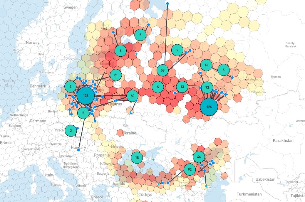
Yes, GNSS and GPS jamming is real, and it is becoming more common almost everywhere. What used to be a rare annoyance is now a daily — even hourly — event. Both intentional jamming and unintentional interference are constantly disrupting aviation, maritime operations, telecom networks, and other critical infrastructure that quietly depends on satellite positioning, navigation, and timing. The scale is hard to grasp until you look at the numbers: analysts in 2025 documented more than 1,500 flights affected by GPS interference every single day, and over 122,000 flights impacted in the first period studied. Public monitoring projects like GPSJAM publish daily maps that grade interference levels — Low (0–2%), Medium (2–10%), and High (above 10%) — giving analysts a rough but useful sense of where the problem clusters and how it shifts over time.
Those maps use a simple scale: Low means 0–2 percent of aircraft are reporting degraded navigation accuracy, Medium covers 2–10 percent, and High is anything above 10 percent. Once you know how to read it, the concentration of high readings around conflict zones and certain port and border areas is not subtle — it jumps out at you. That's why I check the map before long trips and before trusting any single-source position log. The pattern of interference shifts week to week rather than staying fixed, so a route that looked clean last month can light up without warning, and a log that seemed reliable yesterday deserves a second look today.
Who Uses GNSS Jammers and Why?
Motives range from criminal to military. Cargo theft and vehicle hijacking crews use jammers to blind tracking devices before moving a load. State actors use larger systems to deny or confuse navigation over wide areas. Privacy-motivated individuals buy small units to defeat fleet telematics or parental tracking. Drone operators and counter-drone teams both have reasons to interfere with positioning signals.
The consequences spill far beyond the intended target. Documented risks include cargo theft, vehicle hijacking, drone crashes, prevention of 911 calls, telecom and infrastructure disruption, maritime navigation disruption, and aviation safety risks. A jammer bought to hide one truck can degrade a harbor's timing reference or an airport's approach guidance. That asymmetry, tiny cost against broad harm, is why regulators treat these devices as a public safety problem rather than a personal privacy tool.
How Do You Tell If You Are Being Jammed?
Detection signs include a NO FIX message, inconsistent positioning, unrealistic speed over ground or course over ground changes, time sync problems in AIS, GMDSS, or ECDIS, multiple receivers affected at once, and receiver interference alerts. The strongest clue is simultaneity: when several independent receivers in the same area degrade together, the problem is almost certainly local interference rather than a satellite fault.
Resilience rests on four pillars: multi-constellation multi-frequency receivers, signal authentication such as Galileo OS-NMA and GPS Chimera, proactive detection and geofencing, and sensor fusion with inertial navigation and alternative PNT sources. The table below summarizes how the leading anti-jamming products approach the problem.
| System | Core capability | Frequency coverage | Notable spec |
|---|---|---|---|
| infiniDome GPSdome | Detects and counters simultaneous jamming sources | Dual band L1/L2 or L1/G1 | Up to three jamming sources, ~100 ns latency |
| NovAtel GAJT | Null-forming to preserve satellite view | Multi-band configurations | Rejects interference before the receiver |
| Septentrio AIM+ | Real-time interference monitoring and mitigation | Multi-frequency receivers | On-receiver detection and alerting |
The takeaway from that comparison is that no single layer is sufficient. Null steering handles one strong source well but struggles with multiple directions. Authentication catches spoofing but not noise. Fusion with inertial sensors buys minutes of usable output during an outage, not hours. Layering them is what turns a fragile fix into a defensible one.
Is GPS Jamming Illegal, and What Are the Limits of Protection?
GNSS jamming is illegal in the United States and most countries, yet jammers remain readily available online despite that illegality. Enforcement is difficult because the devices are small, cheap, and often shipped as generic electronics. Buying one is not a clever privacy hack; it is a regulatory violation with real liability, and in the US the FCC has repeatedly moved against sellers and operators alike.
Even lawful, well-funded defenses have limits. Anti-jamming gear reduces exposure but cannot guarantee service in a saturated environment, and no receiver can promise performance when every GNSS band is flooded. The practical posture is layered resilience plus honest expectations: know your failure modes, keep alternative PNT options available, and treat any single-source position as one input among several rather than as ground truth.
Frequently Asked Questions
What is GNSS jamming?
GNSS jamming is intentional radio frequency interference that broadcasts powerful signals on the same bands used by GNSS satellites. These noise signals overwhelm weak satellite transmissions, preventing receivers from locking on and calculating accurate position, navigation, or timing data. Because satellite signals arrive below background noise, even a low-power transmitter can cause a loss of fix across a wide area.
How does GNSS jamming work?
A jammer transmits radio frequency signals at GNSS frequencies but at higher power. Because GNSS signals arrive extremely weak from orbit, even a low-power jammer can overpower them, making it impossible for the receiver to distinguish the legitimate signal from interference. One watt can disrupt reception for several kilometers, and a few milliwatts can cover hundreds of meters.
What is the difference between GNSS jamming and spoofing?
Jamming overwhelms GNSS signals and causes loss of signal or position. Spoofing generates fake GNSS-like signals that trick receivers into computing incorrect positions or times. Jamming causes denial, while spoofing feeds false data and can go unnoticed without detection. Defenses differ too: null steering targets interference, while authentication schemes such as Galileo OS-NMA target spoofing.
Does GNSS or GPS jamming happen often?
Yes. GNSS and GPS jamming is real and increasingly common worldwide. Both intentional and unintentional interference now occur daily and every hour, affecting aviation, maritime, telecom, and other critical infrastructure that relies on GNSS. Public maps such as GPSJAM show persistent interference clusters around conflict zones, ports, and border regions rather than isolated one-off events.