Low-altitude airspace security protects the airspace from the ground to about 500 feet using layered sensors, fusion software and clear response rules. This guide breaks down how counter-UAS works, what each sensor layer contributes, and where programs still fail.
What Is Low-Altitude Airspace Security and Why Does It Matter?
Low-level airspace security, then again, is about securing and observing the air space closest to earth — as a rule from ground level up 500 feet around an area/way/_occasion. For the detection, tracking and identification of small drones or other low-altitude issues it combines sensors with software as well pre-agreed response rules operated by trained operators. The number one way in which I see this mistake manifesting is people view it as hardware (even you might have the faculties to distinguish between risk and system).
Low-altitude airspace security has become such a pressing topic largely because of geometry: small unmanned aircraft systems, or sUAS, add a third dimension that ground-based security was never designed to handle. A drone can cross a fence line, a highway, or a property boundary in seconds, which makes the usual layered perimeter—fences, cameras, guards—mostly irrelevant to the threat overhead. These aircraft also tend to be low, slow, and small, so they appear without warning and often stay invisible to a traditional air traffic system built around larger, faster aircraft that cooperate with tracking. The airspace in question is usually defined as everything from the surface up to about 500 feet, and it generally accommodates UAS operations within 400 feet above ground level, though some operational envelopes reach 1,000 feet. Above that, the picture shifts again: IEEE TNSE has described low-altitude economy operations at altitudes between 1,000 and 3,000 meters, a band where new commercial uses are already being planned.
Scale is part of the problem here, and it cuts both ways. On the manned side, about 96 percent of low-altitude airspace has no mandated electronic conspicuity requirement. That means a lot of aircraft in that band—crop dusters, police helicopters, banner tow planes, private pilots flying VFR—never announce themselves electronically. Whether they show up on radar depends entirely on where you're standing. Now stack commercial drone traffic on top of that. On August 17, 2026, Zipline and Uber announced a target of one million drone deliveries a day by 2029, which would turn quiet suburban corridors into something closer to a conveyor belt. Every one of those flights is legitimate, and every one of them has to be kept apart from the handful that aren't. That's the real difficulty: more routine flights mean more legitimate traffic to sift from genuine threats. A system that treats every new aircraft as suspicious will drown its own operators in noise long before it ever catches a bad actor.
The public reacts quickly as well if something seems wrong. The panic that gripped New Jersey in late 2024 led to more than 5,000 citizen reports of potential drone activity most of which were common aeronautical vehicles shipped or constructed models. And that difference between perception and reality is precisely why low-altitude security has to be a risk management system, not a guarantee of removing the unknown aircraft. The goal is to support timely, proportional and auditable decision activity.
How Counter-UAS Supports Low-Altitude Airspace Security
A C-UAS program, in general terms is better understood as a combine of tech and governance (not just an out-the-box system you can bolt to your roof!) Sensors like radar, RF and EO/IR produce raw observations a blip here, control link there, thermal signature over yonder. Fusion software then layers those observations into intelligent tracks and goes to work in reducing false alarms so that operators aren't spending their days chasing birds or treetops. Trained operators then consider the context: Hobbyist going off course, delivery drone on a filed route or just something that needs looking at? The final call is made by accredited bodies, and that determination has to be reasonable and auditable — sufficiently recorded to withstand scrutiny. Based on my experience auditing these programs, the most insecure part is rarely technology. Ownership, escalation paths and legal authority usually are. The radar may shine brightly on demo day, but what does it mean if no one has agreed whose air picture we have a right to own or who gets the 2 a.m. wake-up call and especially who's legally allowed to act when track goes hot?
The core workflow is detect, track, and identify — usually just called DTI. Each of those verbs does its own job. Detection is the first step, and it answers a pretty basic question: is something actually out there? Tracking comes next, telling you where that object is headed and whether the track holds steady or keeps breaking apart. Identification goes further still, answering what the object is, who's flying it, and whether the intent behind it is hazardous, just a violation, or genuinely hostile. Those three labels aren't interchangeable, and treating them as if they are is exactly where counter-UAS programs get themselves into trouble. A hobbyist who drifts a little off course, a commercial operator cutting a corner on the rules, and someone deliberately probing a protected site all call for very different responses. Lump them into one category and you'll end up overreacting to the hobbyist while underreacting to the real threat. Getting DTI right means keeping detection, tracking, and identification distinct at every stage of the workflow, so that the response actually matches the risk in front of you.
Mitigation is where counter-UAS programs get politically and legally messy, because the options sit on a spectrum from soft to hard. At the gentle end, Cyber over RF (CoRF) identifies a rogue sUAS and takes control of it by interacting directly with its communication protocol, steering the drone to a safe landing or redirecting it without the collateral damage that jamming can cause to nearby networks. Then things escalate: jamming, spoofing, net capture, and — in some jurisdictions — kinetic neutralization. Louisiana gave a good sense of how fast the legal ground is shifting when it authorized police to neutralize malicious drones in 2025, even as federal rules remain uneven from state to state.
| Mitigation option | How it works | Relative intrusiveness |
|---|---|---|
| Cyber over RF (CoRF) | Interacts with the rogue UAS communication protocol to take control, enabling safe landing or redirection without jamming collateral | Low |
| Jamming | Disrupts control or navigation signals | Medium to high |
| Spoofing | Feeds false signals to misdirect the drone | Medium to high |
| Net capture | Physically entangles the drone in flight | High |
| Kinetic neutralization | Destroys or disables the drone by force; Louisiana authorized police to use it against malicious drones in 2025 | Highest |
하튼 실시강도에 깜짝 놀라는 수치가 정말 팩트이기는 하다. The FAA Reauthorization Act of 2024 did raise the civil penalty cap to $75,000 per violation — that is something actual regulators around here are glad about (a good thing too). Yet, as welcome a measure it may be to have steeper fine schedules in place for violators — that doesn't address the underlying issue: identifying something floating around in the atmosphere is not tantamount with being empowered to do anything about them. And it is perfectly possible for someone to detect a drone, track its output and identify who was behind the controls without having standing under UK law in order to jam that signal or intercept/detain/crash the drone itself. It is that window from observation to action which accounts for many of the failures in counter-UAS programs when hardware is deployed before agreement on ownership and command authority has been codified. Hardware takes weeks to arrive; a clear chain of command, roles on paper, and legal sign-off generally take much longer — skipping that groundwork means operators are watching threats they have no power to touch.
Key Technologies: Radar, RF, Remote ID, LiDAR and Multimodal AI
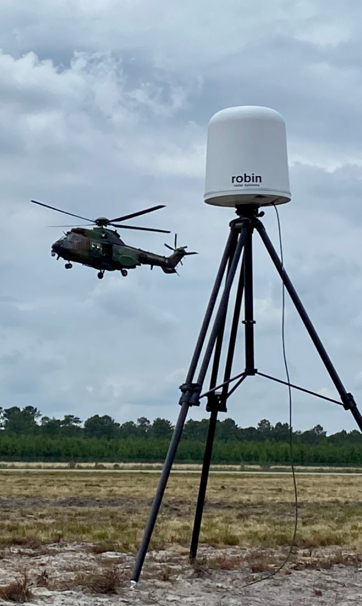
Not a single sensor is perfect for every low-altitude challenge, which is exactly why credible architectures combine them. Radar uses reflected radio waves to determine range, speed and three-dimensional positioning; modern C-UAS radars smartly filter out clutter (such as birds or trees) from the radar view. RF detects transmitter and control links to help locate a pilot. Electro-optical and infrared cameras are useful to corroborate what has been released in an opening report (or can be used against you in a court).
Remote ID is the least expensive cooperative layer in the stack: it broadcasts a drone's identity, where it has been and what control equipment (if any) it is operating under as Wi-Fi or Bluetooth signals to upgrade agents with a low-cost way of determining which planes operate independently from those that are restrained. But it isn't a panacea, because mute dark drones that never transmit are still undetectable. Unlike this passive approach, LiDAR fires laser pulses in order to construct 3-dimensional maps of the airspace with high resolution and therefore it is excellent for tracking&mapping obstacles. The downside is range and weather: LiDAR has a shorter range compared to other sensors, one of the reasons it can't operate in fog or heavy rain but it's perfectly fine as point defense/ gap-filling tool while having limited wide-area search capability. Multimodal AI enhances single sensor effectiveness while simultaneously improving intent detection and lowering false alarms through the fusing of optical, thermal and RF data. Add in ADS-B, the standard to eliminate confusion as to who is up there flying around and that cooperative picture gets a darn sight more credible.
Vendor specs are where the differences between these sensing layers stop being theoretical and turn into actual numbers. The table below gathers representative capabilities from the source material, which makes it easier to see just how far apart the options really are—from an ultra-long-range LiDAR that reaches out to 4,000 meters (customizable, depending on the setup) to a low-SWaP AESA radar with an onboard GPU that classifies low, slow, small drones in real time and links multiple units for 360-degree coverage. Interceptor platforms like DroneHunter add yet another layer, launching within seconds with modular NetGun or DrogueNet payloads under radar and AI guidance, while DroneHangar keeps those assets charged and climate-controlled for automatic deployment around the clock. Still, treat these figures as configuration-dependent: terrain, weather and how the system is installed all shift real-world performance, which is exactly why procurement should start with interfaces and roles rather than a single headline range number.
| Technology | Primary Role | Representative Spec | Known Limitation |
|---|---|---|---|
| LSLiDAR MS Series | Ultra-long-range low-altitude surveillance | Detects objects up to 4,000 meters (customizable), 1550nm fiber laser | Degraded by fog and heavy rain |
| TrueView Radar | Low-SWaP AESA search and track | Onboard GPU for real-time classification and 3D detection; multiple units link for 360-degree coverage | Needs fusion to confirm intent |
| DroneHunter | Interception and capture | Modular NetGun and DrogueNet payloads, launches within seconds, guided by TrueView R20 and AI autonomy | Requires clear rules of engagement |
| DroneHangar | Persistent readiness | 24/7 charging and climate control with automatic deployment in seconds | Adds site and power footprint |
The practical takeaway is that radar is strongest for wide-area search and track continuity, RF reveals the control link and often the operator, and EO/IR supplies the visual proof. A layered defense typically pairs radar for long-range detection, CoRF for precise identification and mitigation, and EO/IR for verification. Sensing alone is insufficient if operator workflow, handoff logic or response rules are weak.
System Architecture: Layered Sensing, Fusion and Command Workflow
A workable architecture starts by defining the protected airspace in operational terms rather than abstract range circles. I ask site teams to describe what they actually care about: a substation footprint, a runway approach corridor, a stadium bowl, a delivery route. That definition drives sensor placement far more reliably than a vendor's maximum detection range.
From there, the architecture has five layers: airspace context, sensing, fusion and correlation, command workflow, and response integration. Each sensor gets an explicit role, so nobody expects a thermal camera to perform wide-area search. Fusion and command are first-class layers, not afterthoughts bolted onto a radar feed. In my experience, programs that skip this step end up with five dashboards and no single track picture.
Interfaces should be defined before procurement. That includes track and event message formats, time-reference requirements, camera-cue control paths and latency budgets. Writing these down early prevents the classic failure where a radar vendor and a camera vendor both claim compatibility but neither supports the same timestamp standard.
Finally, build for degraded operation. RF congestion, poor visibility, radar masking by terrain and communications loss are normal conditions, not edge cases. A program that only works on a clear day with perfect connectivity is not a security system; it is a demonstration.
| Layer | What It Delivers | Typical Owner |
|---|---|---|
| Airspace context | Defined protected volume, rules and thresholds | Site owner and aviation authority |
| Sensing | Radar, RF, EO/IR, LiDAR, Remote ID observations | Security operations |
| Fusion and correlation | Single track picture, false-alarm reduction | Security operations and IT |
| Command workflow | Assessment, escalation and audit trail | Security operations and law enforcement |
| Response integration | Mitigation, notification and reporting | Authorized agency and legal team |
Challenges: Dark Drones, Clutter, Weather and Regulatory Gaps
Dark drones are the hardest problem. An aircraft that transmits neither RF nor Remote ID is effectively invisible to passive sensors, leaving radar and EO/IR as the only options. Even then, small airframes with low radar cross-sections blend into clutter. This is why detection ranges quoted in brochures should always be tested against the actual site, not assumed.
Environmental sensitivity compounds the issue. LiDAR and optical sensors degrade in all-weather conditions, and heavy rain or fog can cut effective range dramatically. RF detection struggles in congested spectrum environments where legitimate transmitters crowd the band. ADS-B helps resolve some ambiguities, but it only covers aircraft that are equipped and broadcasting.
Regulatory gaps remain significant. There are no harmonized federal guidelines for protecting certain critical infrastructure sectors such as private power grids, and FAA restriction laws prevent full C-UAS deployment at substation sites. NERC CIP-014 addressed physical attacks on substations, but no parallel standard exists for drone or airspace threats. As of May 2026, the Part 108 BVLOS rule was still in late-stage rulemaking, and LAANC covered roughly 740 air traffic facilities as of 2026.
Aviation safety is not hypothetical. The mid-air collision at Washington Reagan Airport on January 29, 2025, underscored how crowded and consequential low-altitude operations have become. For security teams, the lesson is that airspace awareness is now part of operational risk, not a specialist side project.
Stakeholders and Governance in a Counter-UAS Program
Stakeholders in a counter-UAS program include the site owner, security operations, the aviation or airspace authority, the spectrum authority, law enforcement, IT and cybersecurity teams, and privacy or legal counsel. Each brings a different constraint. Security wants coverage, legal wants authority, IT wants network integrity, and privacy teams want to know what data is retained and for how long.
Governance is what turns those constraints into a workable program. That means documented roles, written escalation criteria, retention policies and a clear record of who can authorize which response. The U.S. Department of Homeland Security has published counter-UAS guidance emphasizing layered detection and coordinated response, and the FAA maintains restrictions on where mitigation is legally permitted.
I have seen programs succeed when a single accountable owner chairs a recurring review that includes legal and aviation representation. They fail when equipment is installed before ownership is agreed, or when the security team is expected to make legal judgments in real time. Timeliness signals matter too: America's low-altitude awareness gap was flagged in an August 25, 2026 article, and system architecture guidance published May 5, 2026, stressed the same interface-first discipline.
The bottom line is that low-altitude airspace security is a governance problem wearing a technology costume. Sensors matter, but the decision chain behind them determines whether a program protects people or just generates alerts. This article does not constitute investment advice.
Frequently Asked Questions
What is low-altitude airspace security?
It is the practice of monitoring and protecting airspace close to the ground, typically from the surface to 500 feet, around a site, route or event. It combines sensors, software, operators and response rules to detect, track and identify small drones and other low-altitude threats.
How does a counter-UAS system work?
A counter-UAS program combines technology and governance. Sensors such as radar, RF and EO/IR create observations; fusion software correlates tracks and reduces false alarms; trained operators assess context; and authorized organizations decide on a proportionate, auditable response.
Why is low-altitude airspace a distinct security domain?
Small unmanned aircraft add a three-dimensional route that can cross physical boundaries quickly. They fly low, slow and small, appear unpredictably, and are often invisible to traditional air traffic systems, so ground perimeter security alone cannot cover the risk.
What technologies are used for low-altitude airspace security?
Common layers include radar for wide-area surveillance and 3D positioning, RF detection for control links and signals, Remote ID for cooperative identification, EO/IR cameras for visual confirmation, LiDAR for short-range 3D mapping, and multimodal AI for intent recognition and false-alarm reduction.